Hike To Utah’s Stunning Candy Cliffs With This Guide To Yant Flat Trail

Stepping onto the trail after leaving your vehicle at the Yant Flat parking area is a ticket to a remote experience far far away from the fast-paced modern world we are immersed in each day. In only a few short miles, you are transported to a colorful world of adventure and exploration among the Candy Cliffs. Experience what makes Utah so special away from the crowds on this low-traffic trail. This article provides you with everything you need to know to plan your excursion to Yant Flat and the Candy Cliffs in southern Utah!
About The Yant Flat Trail

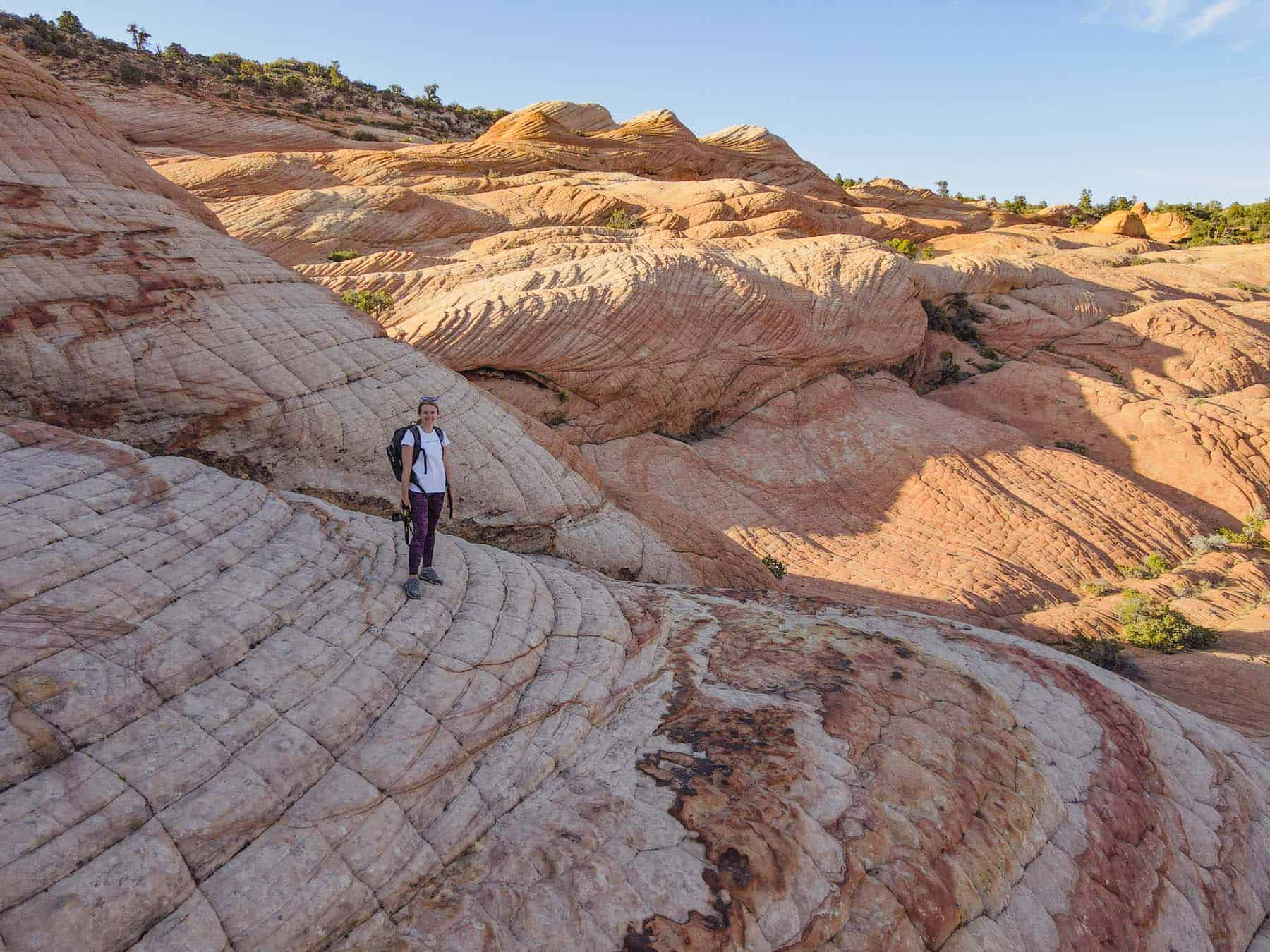
Utah’s Yant Flat Trail is a gateway to one of southern Utah’s hidden gems. One of the most unique features of the hike is the “Candy Cliffs” with their striking rock formations, which resemble brightly colored candy. The rocks are made up of sandstone and contain a variety of minerals and metals that give them their distinctive hues. As you make your way along the trail, you’ll encounter a variety of rock formations including colorful domes and daunting cliffs while getting lost in a sea of candy and stone.
Where Is It

Located in the Dixie National Forest and within the Red Cliffs National Conservation Area not far from St. George, Utah’s Candy Cliffs feel like a hidden gem tucked away off an unassuming dirt forest road.
For the explorer searching for unmatched beauty that leaves you feeling like you have been transported to another planet or the individual searching for seclusion and quiet where they can reflect or find inspiration, this trail is for you.
GPS Coordinates
Yant Flat Parking & Trailhead: 37.23439, -113.4768
Candy Cliffs: 37°13’12.7″N 113°28’22.0″W
Map
How To Get To The Yant Flat Trailhead

Driving to the Yant Flat Trailhead requires a long bumpy ride on a washboard forest road (FR-031), no matter which way you arrive. You can most likely access the trailhead in normal conditions without a 4×4 vehicle, just know it is an unmaintained road with large potholes.
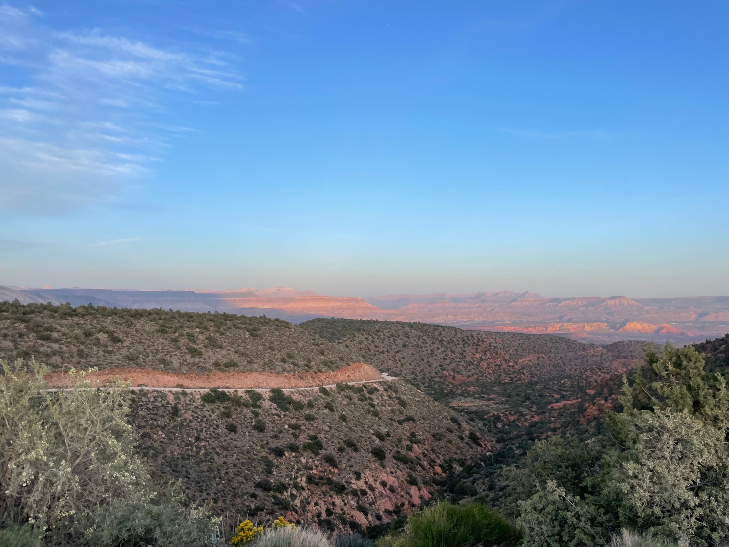
We drove up to the trailhead in our 4WD dually from St. George and enjoyed a beautiful ride through the wide-open fields and sweeping vistas in the Red Cliffs National Conservation area. We returned from the trail through the twists and turns and dramatic views of Hurricane Utah sitting below. It was not the most comfortable ride and had a few hair-raising turns, but we made it! And it was a truly breathtaking journey.
If arriving from St. George you will see a dirt pull-out for parking before the opening of the trailhead, with views of Signal Peak to your left.
From Leeds, you will potentially see some parking right where the Yant Flat Trailhead is, or just after, with views of Signal Peak up to your right.

Driving Directions Map
From St. George, Utah
From Leeds, Utah
Getting To The Candy Cliffs

Getting to the infamous swirls of colorful rocks does require a bit of effort. You can only view and access these features by hiking out to them!
Once you park, you will start on a dirt trail through desert vegetation among the southern slopes of the Pine Valley Mountains. Once you reach an overlook where you are treated to stunning views of the Red Cliffs National Conservation area to the west and West Mountain Peak, you know you are almost there!

Just a little bit further on a sandy trail and you will emerge at the edge of the Candy Cliffs and be invited into a land of wonder and free-form exploration that will inspire your curiosity and test your agility. Next, we dive into the specifics of completing this trail and making the most of this truly unique and colorful hike.
Hiking The Yant Flat To Candy Cliff Trail

Hiking from Yant Flat to the Candy Cliffs is an experience unlike any other. With its unique rock formations, vibrant swirling hues of orange, red, pink, and yellow, breathtaking views, and challenging terrain, this trail is perfect for hikers looking for a one-of-a-kind Utah adventure.
What makes the Candy Cliffs so unique? Sandstone layers at the edge of the Colorado Plateau have been pushed up by volcanic rocks and eroded into the colorful domes and cliffs hikers see today. Here you can see beautifully marbled patterns in the rock formations, with some of the most breathtaking colored sandstone formations we have seen in Utah.

Hike Details
- Type: Out and Back
- Distance: 3.4 miles-7 miles, depending on the route and how much you explore
- Duration: 2-5 hours
- Difficulty: Moderate (we found the most difficult part of the trail to be navigating the swirled rock of the candy cliffs, where you will encounter steep drop-offs)
- When To Go: Spring, Fall, & Winter for mild temperatures

Trail Map
There are a few different options for hiking in this area of the Dixie National Forest. Due to the limited cell service in the area and poorly marked trails, we highly recommend downloading an offline map (we use AllTrails). For a shorter hike, you can follow the 3.4-mile Yant Flats Trail. For a bit more exploration, you could take the trail to Yellow Top (below). Once you pass Yant Flat and arrive at the Candy Cliffs area, there is no clear trail to follow. You are free to explore wherever you’d like!
Yant Flats to Candy Cliffs and Yellow Top

What To Pack
- Water
- Snacks
- Hiking shoes with good grip for exploring the rocks
- Sunscreen
- Hat
- Sunglasses
- Headlamp or flashlight if you want to stay for sunset or catch the sunrise (which we recommend for the best colors)
- Battery bank to keep the phone charged for navigation
- Offline map for navigation without cell service
- Satellite SOS capable phone or personal locator beacon like the Garmin InReach
- Camera and drone. This area is so picturesque and you will want to capture it!

What To Know Before You Go
- There are no facilities or amenities at the trailhead; this is a remote trail
- It is easy to lose the trail. Especially when exploring the Candy Cliffs, make a note of where you entered from the Yant Flat Trail so you can find your way back
- The trailhead is unassuming so drive slowly when you arrive so that you don’t miss it
- The forest road is bumpy (lots of washboard areas) and narrow; 4X4 recommended and take caution if has recently rained as FR-031 can get muddy and washed out
- Expect limited or no cell service for most of the drive and hike
- This is a great spot for sunrise or sunset to see how the colors of the rocks change in golden hour light
Other Places To Experience In The Area

Zion National Park: A beautiful National Park that shouldn’t be missed! You could easily spend a week just hiking in the park, but we loved venturing outside the park to other beautiful trails in the area with fewer visitors. In the park, hiking The Narrows is a unique experience that is still one of our favorite memories from this area of the country.
Sand Hollow State Park: We loved camping at the Sand Hollow State Park Campground, as well as taking our kayak out on the reservoir. This is also a popular place for boating and riding off-road vehicles like UTVs.
Kolob Canyons District of Zion National Park: A lesser visited section in Zion National Park easily accessible from Hurricane or St. George. We loved exploring the trails into the canyons and climbing up to views down into the main section of the park.
Snow Canyon State Park: A unique state park that many argue would be a National Park if Zion wasn’t so close by (it shares the same history and geology!). Explore Navajo sandstone cliffs, black lava rock and lava fields, and petrified sand dunes as well as camping and hiking.
Quail Creek State Park: Another great local state park perfect for camping, boating, and fishing. The park also has a few hiking trails
Dixie National Forest: There are plenty of other great trails in the Dixie National Forest that provide an escape from busier hiking areas in Zion National Park! You can see a list of some of the top-rated trails on AllTrails
Kanarra Falls: Permitted waterfall hike in the Spring Creek Canyon Wilderness study area that is well-known and very popular.
Campgrounds & Free Camping Near St. George, Hurricane & Leeds, Utah
Looking for a great place to stay while exploring this area of Utah and enjoying Yant Flat, Candy Cliffs, and the other great parks and hiking trails nearby? You can’t go wrong with immersing yourself in all of this area’s beauty by camping. We love camping on BLM land and in State Parks to get us as close to nature as possible. Here are a few examples of this kind of camping in the area:
Free Camping
- Camp in the Dixie National Forest. We saw cars, tents, and some small RVs camping along FR-031 with amazing views. Follow signage and practice leave no trace
- Hurricane Cliffs Dispersed Camping
- Horseman Park Dispersed Camping
Campgrounds
Fulfilling Travel Tips
Hiking the Yant Flat Trail to Utah’s colorful “Candy Cliffs” is more than just a hike. It is an experience. Wrapped up in one moderate trail, you get an escape into a remote area of undisturbed nature, a unique colorful landscape with endless opportunities for exploration, mountain views, sweeping vistas, a glimpse into this area’s geological history, and peaceful seclusion.
If you embark on an adventure to Yant Flat and the Candy Cliffs, our tip is to not just make it a bucket list item that you check off, but allow yourself the time to slow down and truly experience it.
Sit back and watch as the colors change under the setting sun, take a few deep breaths while soaking in the panoramic views from different vantage points, and give yourself permission to explore freely. This colorful playground of swirled cliffs and domes is the perfect place to reconnect with yourself and the world around you and step away feeling refreshed, grounded, and fulfilled.

Please protect these areas – for the wildlife, the environment, and for the enjoyment of future generations. Practice Leave No Trace


