Top Hikes Near Skyline Drive Virginia: Explore Shenandoah

Shenandoah National Park is home to the famous Skyline Drive that cuts 105 miles across the ridgeline of the Blue Ridge mountains that make up this beautiful park.
Unlike some National Parks where hikes are located in different areas all over the park, Skyline Drive offers easy access to amazing hiking with an easy way to park right at the trailhead for some of the park’s best trails.
With miles of trails just steps from the scenic Skyline Drive, it is easy to venture into the heart of Shenandoah National Park and experience its magic.
After multiple visits to this serene park, we are sharing the best hikes near Skyline Drive Virginia that will leave you in awe and inspire you to spend more time exploring nature!
About Shenandoah National Park

Shenandoah National Park is a lush natural paradise and playground for the outdoorsy located in the Blue Ridge Mountains of Virginia, USA. Covering an area of 200,000 acres, the park boasts a diverse range of landscapes, including scenic mountain vistas of the Shenandoah Valley, dense forests, and cascading waterfalls.
You can explore the park through its 500 miles of hiking trails, including a section of the famous Appalachian Trail that runs through the heart of the park, or take a scenic drive along Skyline Drive, which runs the length of the park’s ridgeline. The park is also home to a rich variety of wildlife, including black bears, deer, and numerous bird species.
The park is well-marked with mile markers, which is a great way to identify various trails and scenic overlooks. You will see a mile marker listed for each trial below, to help you navigate to these bucket list-worthy trails that can be easily accessed right off Skyline Drive.
Shenandoah National Park Entrances
Depending on where you plan to stay and what hikes you want to do, Shenandoah National Park can be accessed through four different entrance stations.
- Front Royal Entrance (north entrance) at U.S. 340
- Thornton Gap Entrance at U.S. 211
- Swift Run Gap Entrance at U.S. 33
- Rockfish Gap Entrance (south entrance) east of Waynesboro off U.S. Highway 250
As a starting point, you might consider stopping at the Dickey Ridge Visitor Center or Byrd Visitor Center to help you learn more about the park from the National Park Service, speak to rangers about the best trails during your visit, and find out about trail conditions
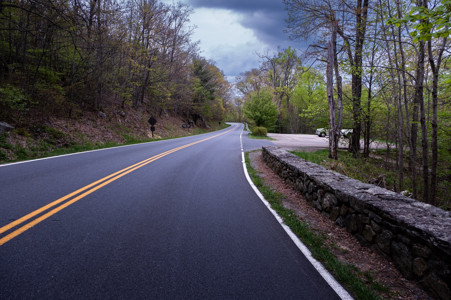
About Shenandoah’s Skyline Drive

Virginia’s Skyline Drive is the only road that runs directly through the entire length of Shenandoah National Park. Winding its way 105 miles along mountain ridges offering spectacular sweeping views of the soft forested valleys and peaks of the surrounding Blue Ridge Mountains, Skyline Drive stretches north from Front Royal Virginia all the way south to Waynesboro.
It is a well-marked and nicely paved road with mile markers that help you navigate between the many trailheads located along the road, while also being full of scenic overlooks and pullouts.
We recommend driving slow with the windows down (if the weather is favorable), allowing the breeze and the mountain fresh air to engulf your car. Bring the outdoors inside for a while as you travel to the hikes that will allow you to explore the park on foot and truly get a feel for the beauty of the landscape.
Landmarks along Skyline Drive:
- 2 Visitor Centers
- 1 Lodge with rustic dining options
- 4 Additional Wayside Dining Options
Best time to visit:
As full-time RVers, we tend to follow the weather with our travel plans while also aiming to visit large parks in the shoulder season when the crowds are not as bad.
We really enjoyed our visit to Shenandoah National Park at the end of April into the first week in May. We were treated to mostly empty trails, rushing waterfalls, bright green foliage blooming wildflowers, sunny days, and mild weather.
While we highly recommend visiting Shenandoah during the shoulder seasons, here is a bit of what you can expect throughout the year:
- Spring (March to May): Spring brings blooming wildflowers, budding trees, and cascading waterfalls. The park comes alive with vibrant colors, and wildlife activity increases. The temperatures are generally mild, but rain showers can be common, making trails muddy and slippery. We found it to be an excellent time for hiking and enjoying the park’s natural beauty.
- Summer (June to August): Summer in Shenandoah National Park is warm and humid, with temperatures ranging from comfortable to hot. The park is lush and green, and the visitor facilities, including campgrounds and amenities, are fully open. Summer is a busy season, so you can expect larger crowds on the trails and more difficulty finding parking.
- Fall (September to November): Fall is another popular time to visit Shenandoah National Park due to the stunning display of fall foliage. The mountains transform into a colorful mosaic of red, orange, and yellow. The park can be crowded during peak leaf-peeping season, especially on weekends. Early to mid-October is often considered the prime time for fall colors in this area of Virginia in the Blue Ridge Mountains.
- Winter (December to February): Winter offers a quieter and more serene experience in the park. The landscape can be blanketed in snow, creating a peaceful atmosphere. Some trails and facilities may be closed, but winter hiking and snowshoeing are popular activities. The park’s scenic beauty is enhanced by the starkness of the season.
For a less crowded experience, consider visiting Shenandoah National Park on weekdays earlier or later in the day or during the shoulder seasons (early spring, late fall, and winter). These times offer milder weather, fewer visitors, and the opportunity to enjoy the park’s natural wonders in a more tranquil setting.
About Trailhead Parking Along Skyline Drive
The mile markers are numbered sequentially from south to north, starting at mile 0 in the southernmost part of the park and ending at mile 105 at the northern boundary. They serve as reference points for navigation, communication, and locating specific features or attractions within the park, such as trails and parking areas.
Along Skyline Drive, you will find a range of parking areas for the trailheads located along the road:
- Small Pull-offs: Some trailheads have small pull-off areas designated for parking. These are typically suitable for only a few vehicles and may fill up quickly during peak visitation periods. They are often marked by a sign indicating the trailhead and are intended for shorter or less popular trails.
- Medium-Sized Lots: Many trailheads feature medium-sized parking lots capable of accommodating a moderate number of vehicles. These lots are designed to handle a higher volume of visitors and tend to be located near more popular trails or trail networks. They offer more parking spaces but may still fill up during busy times.
- Large Parking Areas: For the most popular and heavily visited trailheads, Shenandoah National Park provides larger parking areas. These lots can accommodate a significant number of vehicles and are often found near major attractions, such as waterfalls, panoramic viewpoints, or well-known hikes (like Old Rag Mountain). They are designed to handle a larger crowd, but during peak seasons or weekends, they can still reach capacity.
Hiking early or late in the day or during shoulder season can help you secure a parking spot. If you go during peak times, be prepared to park farther away and walk a bit if you plan to explore more popular trails. In our experience, the shorter and easier the hikes, the more crowded they tend to be.
Map of Skyline Drive
Map of Skyline Drive Trails
Skyline Drive runs through the park and connects trails in the park’s 3 major sections: the North District, the Central District, and the South District. This interactive map includes the trailheads and nearby parking areas for all of the hikes near Skyline Drive listed in the article below!
Best Hiking Near Skyline Drive Virginia

The following trails are easily accessed right off Skyline Drive, the main road that cuts through Shenandoah National Park. This is a great starting point to help you build your epic hiking bucket list for visiting the park!
Whether you are looking for scenic mountain views, cascading waterfalls, fun rock scrambles, or easy hikes to beautiful overlooks, you can find it all right off Skyline Drive in Virginia!
Bearfence Mountain Trail (mile marker 56.4 )

A short trail that leads you through multiple sections of fun rock scrambling before leading you to spectacular 360-degree views of Shenandoah National Park, the Virginia Piedmont, and the Shenandoah Valley.
The rock scramble section leads you on some uneven terrain with sharp drop-offs, so those who are afraid of heights may want to consider the route without the scramble (making it an out-and-back trail), although the scramble makes for a fun adventure and the best views. We recommend hiking this trail clockwise!
Bearfence Mountain with Rock Scramble
- Length: 1.0 mile loop
- Elevation Gain: 242 feet
- Estimated Duration: 1-1.5 hours
- Dog Friendly?: No
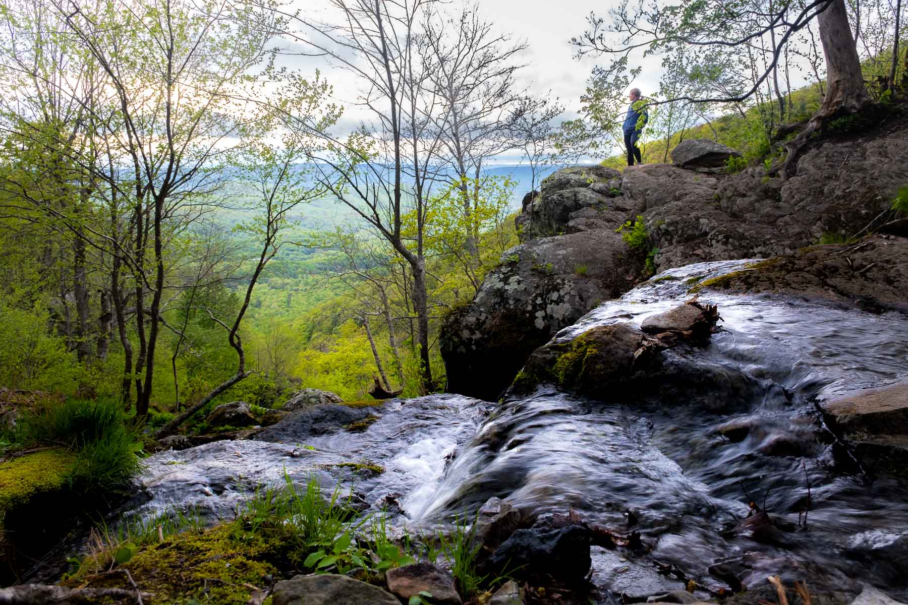
Hawksbill Mountain (mile 45.5)

Hawksbill Mountain is the highest point and highest peak in Shenandoah National Park. With multiple trails leading up to Hawksbill Mountain, you can pick your adventure and be treated to sweeping views of the Shenandoah Valley.
The top is marked by a stone viewing platform where you can see for miles out into beautiful Virginia. Unlike other parks where getting to the highest point would require a long hiking journey, here you can appreciate the remarkable vistas after only a short trek!
- Length: 2.7 mile loop
- Elevation Gain: 744 feet
- Estimated Duration: 1.5 -2 hours
- Dog Friendly?: Yes

- Length: 2.1 miles out and back
- Elevation Gain: 498 feet
- Estimated Duration: 1- 1.5 hours
- Dog Friendly?: Yes
Mary’s Rock (mile 31.6)

The climb to Mary’s Rock from the South approach starts right away with a steep ascent up a series of steps, before winding you through the forest. Following along the single track, you are brought out to Mary’s Rock, where you can precariously climb on the rocks to appreciate the surrounding landscape from another vantage point.
The rocks here have steep drop-offs so be mindful of where you step, especially in wet conditions! If you are wary of heights, there is a flat section for taking in the views as well. The views from Mary’s Rock surprised us in the best way. We almost skipped this trail, but we are so glad we didn’t!
Marys Rock via the Appalachian Trail Southern Approach
- Length: 2.7 miles out and back
- Elevation Gain: 751 feet
- Estimated Duration: 1.5-2 hours
- Dog Friendly?: Yes
For a bit of a longer and steeper hike, you can also do Marys Rock via the Appalachian Trail North Approach
Doyles River Falls (mile 81.1)


The Doyles River Falls trail is a beautiful and rewarding hike along a rocky trail in Shenandoah National Park, featuring not one, but two stunning waterfalls – the Upper Doyles River Falls (63 feet high) and Lower Doyles River Falls (28 feet high). The trail is particularly breathtaking in the spring when the dense, bright green vegetation is in full bloom, and the falls are at their fullest and most powerful.
We felt the trail to the Doyles River Falls was one that left us feeling most removed from the outside world and most immersed in nature. Everything was green, almost as if you were enclosed in an enchanted forest, with nothing but branches and leaves all around.
Doyles River (Upper + Lower) Falls
- Length:3.4 miles out and back
- Elevation Gain: 1,184 feet
- Estimated Duration: 2-3 hours
- Dog Friendly?: Yes
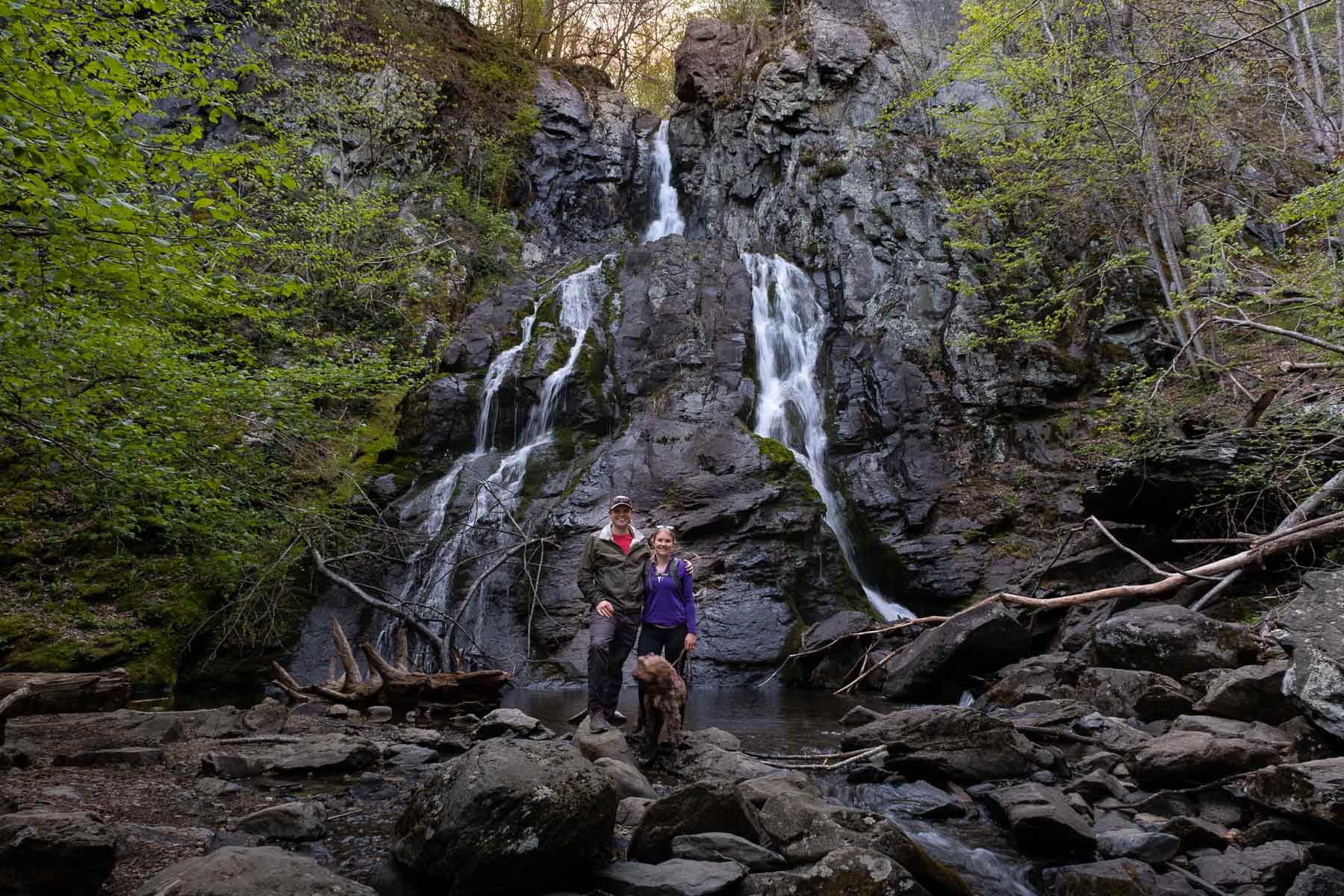
Dark Hollow Falls Trail (mile 50.7)

This is one of the most popular waterfall hikes, as it is easily accessed right off Skyline Drive and requires a short hike to the first viewpoint. Dark Hollow Falls is a beautiful display of multiple cascading sections and is impressive at over 70 feet high and it is easy to see why it is so popular.
Due to the crowds and the landscape that awaits beyond the falls, we feel the best experience is had by continuing down to the very base of the falls and then on past Dark Hollow Falls to Rose River Falls. When done as a larger loop, this trail offers a more peaceful and secluded experience.
- Length: 1.6 miles out and back
- Elevation Gain: 583 feet
- Estimated Duration: 1-1.5 hours
- Dog Friendly?: No
*Note: As this is a popular trail, the Dark Hollow Falls trailhead parking area can fill up quickly. Even on a spring weekday afternoon, the parking area was nearly full. Hiking early or later on the long summer days may be best for this trail!
Rose River Falls Trail (mile 49.4)

The Rose River trail winds through lush forests and over several streams and a picturesque bridge, with several opportunities to stop and enjoy the natural beauty of the surroundings.
Rose River Falls itself is a hidden gem, tucked away in a secluded valley with a private swimming hole at the base of the falls.
- Length: 2.4 miles out and back
- Elevation Gain: 656 feet
- Estimated Duration: 1.5 hours-2 hours
- Dog Friendly?: Yes
To do both Dark Hollow and Rose River Falls in a loop (which we found most fulfilling):
Dark Hollow and Rose River Falls Loop
- Length: 5.1-mile loop
- Elevation Gain: 1,443 feet
- Estimated Duration: 3 -3.5 hours
- Dog Friendly?: No
South River Falls (mile 62.7)
The hike to the South River Falls starts with a sharp descent along a few switchbacks as you follow along the South River, guided by the sound of the falls.
Upon reaching the observation point, you are treated to a partial view of the 83-foot South River Falls (obscured by leaves most of the year). However, we found the true beauty of the falls can only be fully appreciated from the bottom, where you can watch the water as it tumbles down the rocky cliff face, creating a misty cloud of spray that while can be felt from the overlook, can be truly experienced from the base of the falls.
Descending the trail to the bottom of the falls is steep and rocky, with both inclines and declines, however, the view from the bottom of the falls is worth the effort, as you are treated to a breathtaking full view of the South River waterfall and can feel the cool mist on your face.
South River Falls Trail and South River Fire Road Loop
- Parking area: Located in the South River Picnic Area
- Length: 4.6 miles
- Elevation Gain: 1,272 feet
- Estimated Duration: 2.5 -3 hours
- Dog Friendly?: Yes
- Length: 2.5 miles
- Elevation Gain: 757 feet
- Estimated Duration: 1.5 hours – 2 hrs
- Dog Friendly?: Yes
Overall Run Falls (mile 22.2)

Overall Run Falls is the highest waterfall in the park, at 93 feet tall. This hike can be done from Skyline Drive, the Matthew Arms campground, or a boundary trail on the outskirts of the park not far from the Luray Caverns.
While the trailhead on Skyline Drive may be the most convenient, we found starting this hike from the boundary trail to be extremely scenic and quiet, passing across multiple streams in a blooming forest of greens and yellows. We even saw a black bear on the trail!
Upper Overall Run Falls via Matthews Arm Road
- Length: 4.5 miles out and back
- Elevation Gain: 984 feet
- Estimated Duration: 2 hours – 3 hours
- Dog Friendly?: Yes
- Length: 8.2 mile loop
- Elevation Gain: 1,991 feet
- Estimated Duration: 4.5-5 hours
- Dog Friendly?: Yes
Overall Run Falls via Tuscarora Overall Run Trail
- Length: 6.3 mile loop
- Elevation Gain: 1,607 feet
- Estimated Duration: 3.5-4 hours
- Dog Friendly?: Yes
Lewis Falls (mile 51.2)
The Lewis Falls trail is short and one of the easy trails on this list, but is still a rewarding hike in Shenandoah National Park, featuring a stunning 80-foot waterfall.
The trail is easily accessible from Skyline Drive, with only a short distance of trail leading you to an observation point from the top of the falls. While the observation point offers great views of the surrounding mountains, it doesn’t provide a full grasp of the falls itself.
From the observation point, the falls can be seen tumbling down over the rocky cliff, but the rest is truly up to your imagination. We recommend taking the longer loop trail to get a better viewpoint of the falls if this is one of the only waterfall hikes you will be doing in the park.
- Length: 1.7 miles out and back
- Elevation Gain: 656 feet
- Estimated Duration: 1-2 hours
- Dog Friendly?: Yes
- Length: 3.0 mile loop
- Elevation Gain: 872 feet
- Estimated Duration: 1 hr 45 mins – 2.5 hours
- Dog Friendly?: Yes
Short on time or looking for short, easy trails that lead you to great views off Skyline Drive? Consider these other popular hikes that are great for any skill level or a trip with limited time in the park:
Stony Man (mile 41.7)
A short hike to a rocky top with sweeping views of the Shenandoah Valley and Massanutten Mountain.
Stony Man via Appalachian Trail
- Length: 1.5 mile loop
- Elevation Gain: 321 feet
- Estimated Duration: 1-1.5 hours
- Dog Friendly?: No
Blackrock Summit (mile 84.4)
A short, easy trail with limited elevation gain that takes you to a rocky summit with sweeping mountain views. Great for a quick hike if you are short on time or for those just getting out onto the trail for the first time.
Blackrock Summit via Trayfoot Mountain
- Length: 1.0 mile
- Elevation Gain: 175 feet
- Estimated Duration: 45 minutes
- Dog Friendly?: Yes
Appalachian Trail
Training for a thru-hike or want to explore sections of the iconic Appalachian trail? Miles of the Appalachian trail run through Shenandoah National Park, often part of or crossing several of these hikes near Skyline Drive. We even saw the badges of a few thru-hikers who had popped out onto Skyline Drive for a reprieve from the single track!
Our trip to Shenandoah National Park may have left us dreaming of hiking the entire Appalachian Trail one day…
Important Note: If you are driving along Skyline Drive, especially at dawn or dusk, be very careful of the large white-tailed deer population that lives in Shenandoah National Park. They blend in well and are all over the road. Obey the speed limit, be careful around the many twists and turns, and just know they are out there and can dart around quickly!
READ MORE: One Day In Shenandoah National Park
Fulfilling Travel Tips

Shenandoah National Park is a nature-filled playground teeming with waterfalls, wildlife, bright green forests, and panoramic mountain views. In addition to the trails listed above that can be accessed right off Skyline Drive, there are several other great hiking options (check out these 10 Best Hikes in Shenandoah)!
And if you are interested in chasing waterfalls, check out these 14 breathtaking waterfall hikes in Shenandoah National Park as well!
Funny enough, the most popular hike in Shenandoah National Park is a trail that is not accessed via Skyline Drive at all.
Old Rag Mountain is located on the northeast edge of the park, and is so heavily trafficked that the National Park Service has been utilizing a permit system to monitor the flow of traffic on the trail. If you can get a permit, we highly recommend it. Old Rag was one of our favorite hikes in the park!
As full-time RVers, our goal is to have as many immersive experiences in nature as possible. Our biggest tip for visiting Shenandoah National Park is to see as much of the park as possible. If you have the opportunity, arrange for more time in the area to explore all the park districts, the hikes near Skyline Drive, and more remote boundary trails.
A trip through Shenandoah National Park and the Blue Ridge Mountains also makes for the perfect road trip through the stunning mountains that cut through the eastern United States.
If you have time, exploring down to the Blue Ridge Parkway in Western North Carolina can be a great way to fully appreciate what this area of the country has to offer.
PLAN YOUR TRIP TO SHENANDOAH NATIONAL PARK
Entry into Shenandoah National Park requires an entrance fee:
- Cost: $30/vehicle for 7 days
- National Park Passes Accepted
One of the best ways to visit Shenandoah National Park is by camping right in nature!
Shenandoah National Park Campgrounds:
- Big Meadows Campground, Stanley VA
- Loft Mountain Campground, Free Union VA
- Matthews Arm Campground, Luray VA
- Lewis Mountain Campground, Elkton VA
- Dundo Group Campground, Grottoes VA
Other Area Accommodations:
The towns surrounding Shenandoah National Park are full of great campsites, ranging from RV resorts to no-frills campgrounds. If you are looking for the perfect one-stop shop for comparing RV parks and glamping options and prices with instant booking, we highly recommend Campspot.
Our other favorite resources for finding great campgrounds and campsites and reading reviews include Campendium, RV Life, and iOverlander.
Here are some highly-rated private campgrounds not far from Shenandoah National Park:
- Madison Vines RV Resort & Cottages (east of the park in Madison, VA)
- Spacious Skies Shenandoah Views (west of the park off of 81)
- Endless Caverns RV Resort (west of the park off of 81)
- Luray RV Resort on Shenandoah River (west of the park off of 81)
You can also check out HipCamp and TheDyrt for more unique camping experiences and accommodations.
RV Rentals: If you are looking to get closer to nature but don’t have an RV, consider renting one through RV Share. We used this service when renting out our Casita and found them to be high quality and easy to use!
Another great option is glamping if you are looking for a more upscale nature-centric stay. Here are some great options near Shenandoah National Park:
You can explore all Shenandoah National Park area accommodations, including hotels and private rentals, and compare prices on Booking.com, which is a great resource for unique stays at the best rates. Some top towns to consider include:
Looking for inspiration for other great East Coast National Parks to explore? Check out these guides:
- Best East Coast USA National Parks
- Best Trails in Congaree National Park
- Fayette Station Road: New River Gorge National Park’s Scenic Drive
- Best Things To Do in Acadia National Park
- A Complete Guide to Acadia’s Schoodic Peninsula


